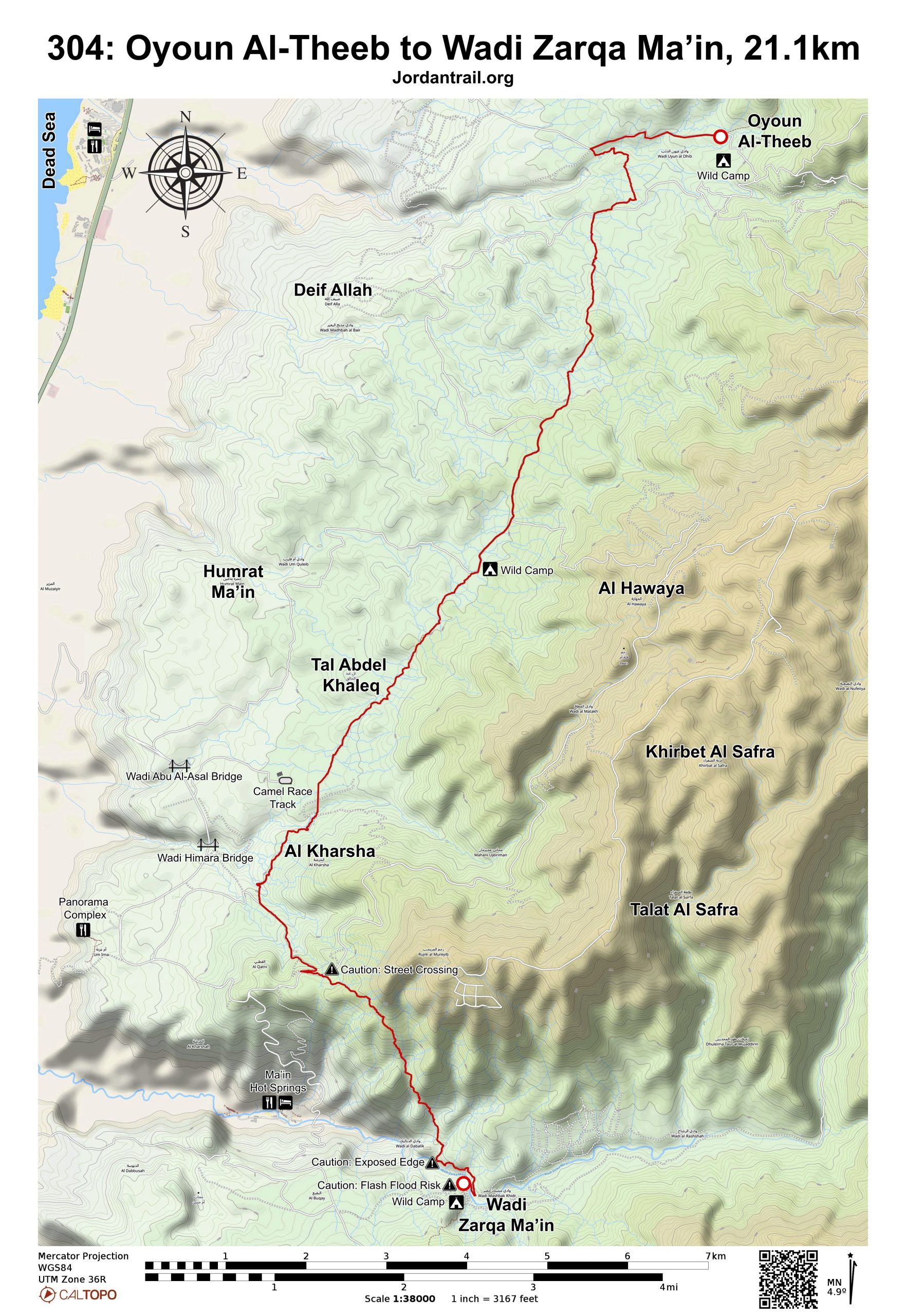
SECTION 304: OYOUN AL-THEEB TO WADI ZARQA MA’IN

  • HIKES IN THE REGION

  • DAY 4: OYOUN AL-THEEB TO WADI ZARQA MA’IN

  • Distance: 21.1 km

  • Time: 7 hours

  • Physical Challenge: Difficult

  • Trail Challenge: Difficult

  • Waymarked: No

To download the GPS track, click icon  

The Jordan Trail is a newly established trail, and is not marked. It is therefore our strong recommendation that you hire a local guide for your safety as many sections are remote with limited water sources and at times no connectivity.
By downloading these maps/GPX you take full responsibility for their use and accuracy; Jordan Trail Association does not warrant the accuracy or completeness of the information, materials or the reliability of any maps as they provided AS IS without warranty of any kind, either express or implied, including but not limited to, fitness for a particular purpose, or non-infringement ;You acknowledge that any reliance on any such maps, shall be at your sole risk and responsibility as Hiking, backpacking, and other outdoor activities all have potential hazards involving risk of injury or death. Outdoor activities have inherent risks and you should ensure you have the skill level and abilities suitable for the activities in Jordan to partake in them and to take all precaution measures.  Check the data on Google Earth or other Apps or Programs before using them.  The Jordan Trail Association shall not be held responsible for any incidents that may occur during your participation in any activity and/or by using any of the maps/GPX.
AGREE
close-link

Click Icon

The Jordan Trail is a newly established trail, and is not marked. It is therefore our strong recommendation that you hire a local guide for your safety as many sections are remote with limited water sources and at times no connectivity.
By downloading these maps/GPX you take full responsibility for their use and accuracy; Jordan Trail Association does not warrant the accuracy or completeness of the information, materials or the reliability of any maps as they provided AS IS without warranty of any kind, either express or implied, including but not limited to, fitness for a particular purpose, or non-infringement ;You acknowledge that any reliance on any such maps, shall be at your sole risk and responsibility as Hiking, backpacking, and other outdoor activities all have potential hazards involving risk of injury or death. Outdoor activities have inherent risks and you should ensure you have the skill level and abilities suitable for the activities in Jordan to partake in them and to take all precaution measures.  Check the data on Google Earth or other Apps or Programs before using them.  The Jordan Trail Association shall not be held responsible for any incidents that may occur during your participation in any activity and/or by using any of the maps/GPX.
AGREE
close-link
to download the map
IMPORTANT NUMBERS

Tourism Police:

Hotline: 117777
What’s App: +962 7 7099 1814

* When contacting Tourism Police for emergency identify that you are hiking the Jordan Trail, state your nationality, location and map name & number.


JTA office: +962 6 461 0999

(Working Hours: 9:00 a.m. to 5:00 p.m., Sunday- Thursday)

BASIC INFO

Easy walking in wild, barren surrounds as you continue S, still close to higher hills to your E, meeting remnants of the old Roman road from Jerusalem to Mukawir, and following a track left of a camel racing track before crossing the upper reaches of Wadi Himmara. On the S side, a track rises up E to meet a road on the skyline, after which the Roman road is found again winding down a surprisingly easy and spectacular descent to above the basalt columned cliffs of the Zerqa Main canyon, which is easily crossed by a path which descends through the cliffs to reach it. The area is dotted with Bedouin camps and you are likely to come across biblical scenes of shepherds grazing their flocks of sheep and goats.

TRANSPORTATION
  • Private transport only. Start of stage and Panorama highway accessible by car. Pickup trucks can access near Wadi Zarqa Ma’in at the stage end, within 1 km depending on the condition of the road at the time.
  • Public buses go from the Amman South bus station to Madaba. Taxis can take you from Madaba to the trail.
ACCOMMODATIONS

Wild camping only

Where the trail enters Wadi Mukheris, there is an average campsite that has little shade and is not too level, accessible by a short walk from the paved road.

The stage end at Zarqa Ma’in has a good camping near the stream on a ledge just above wadi bottom. Water is flowing all year, and should be purified before use. It is likely not possible for a truck to get within 1km of wadi due to washed out conditions on the road.

THINGS TO SEE
Wadis along the stage:
 1. Wadi Mukhaires
2. Wadi Dardur
3. Wadi Himara
4. Wadi Zarqa Mai’n

Roman Road (From Panorama road to Wadi Zarqa Ma’in).

Dead Sea Museum at Panorama Dead Sea Complex (Off the trail, Tel. 0782488880).

FOOD & WATER

Food:

Water:

  • Wadi Zarqa Ma’in (purification required)
  • Few bedouin tents in case of emergency (present in winter only)
 
TIPS & SAFETY

Tips:

  • The route has many small stones and sharper rocks, and it’s easy for blisters to form and ankles to turn if not careful. Boots and poles are recommended.
  • The route is remote and without water until the end. Be sure to plan accordingly with supplies and transportation.

Safety Info:

  • Exposed edges – None; the trail going down Wadi Zarqa Ma’in looks exposed at top, but in reality it is not, only the viewing angle.
  • Flash flood dangers – In crossing multiple wadis, it’s important to be if raining, worth considering waiting in heavy rain.
  • Loose footing – There are slippery and sharp stones various sections.
  • Dehydration/heat exhaustion – With very little shade and low elevation for most of stage, it’s important to start early and avoid in walking in summer.
 
LOCAL CONTACTS

Abu Majed – 0776501901 (Transportation around Wadi Zarqa Ma’in)

The Jordan Trail is a newly established trail, and is not marked. It is therefore our strong recommendation that you hire a local guide for your safety as many sections are remote with limited water sources and at times no connectivity.
By downloading these maps/GPX you take full responsibility for their use and accuracy; Jordan Trail Association does not warrant the accuracy or completeness of the information, materials or the reliability of any maps as they provided AS IS without warranty of any kind, either express or implied, including but not limited to, fitness for a particular purpose, or non-infringement ;You acknowledge that any reliance on any such maps, shall be at your sole risk and responsibility as Hiking, backpacking, and other outdoor activities all have potential hazards involving risk of injury or death. Outdoor activities have inherent risks and you should ensure you have the skill level and abilities suitable for the activities in Jordan to partake in them and to take all precaution measures.  Check the data on Google Earth or other Apps or Programs before using them.  The Jordan Trail Association shall not be held responsible for any incidents that may occur during your participation in any activity and/or by using any of the maps/GPX.
AGREE
close-link