SECTION 803: SHAKRIYA TO WADI RUM

  • HIKES IN THE REGION

  • DAY 3: SHAKRIYA TO RUM VILLAGE

  • Distance: 12.1 km

  • Time: 3 - 4 hours

  • Physical Challenge: Easy

  • Trail Challenge: Easy

  • Waymarked: No

To download the GPS track, click icon  

The Jordan Trail is a newly established trail, and is not marked. It is therefore our strong recommendation that you hire a local guide for your safety as many sections are remote with limited water sources and at times no connectivity.
By downloading these maps/GPX you take full responsibility for their use and accuracy; Jordan Trail Association does not warrant the accuracy or completeness of the information, materials or the reliability of any maps as they provided AS IS without warranty of any kind, either express or implied, including but not limited to, fitness for a particular purpose, or non-infringement ;You acknowledge that any reliance on any such maps, shall be at your sole risk and responsibility as Hiking, backpacking, and other outdoor activities all have potential hazards involving risk of injury or death. Outdoor activities have inherent risks and you should ensure you have the skill level and abilities suitable for the activities in Jordan to partake in them and to take all precaution measures.  Check the data on Google Earth or other Apps or Programs before using them.  The Jordan Trail Association shall not be held responsible for any incidents that may occur during your participation in any activity and/or by using any of the maps/GPX.
AGREE
close-link

Click Icon

The Jordan Trail is a newly established trail, and is not marked. It is therefore our strong recommendation that you hire a local guide for your safety as many sections are remote with limited water sources and at times no connectivity.
By downloading these maps/GPX you take full responsibility for their use and accuracy; Jordan Trail Association does not warrant the accuracy or completeness of the information, materials or the reliability of any maps as they provided AS IS without warranty of any kind, either express or implied, including but not limited to, fitness for a particular purpose, or non-infringement ;You acknowledge that any reliance on any such maps, shall be at your sole risk and responsibility as Hiking, backpacking, and other outdoor activities all have potential hazards involving risk of injury or death. Outdoor activities have inherent risks and you should ensure you have the skill level and abilities suitable for the activities in Jordan to partake in them and to take all precaution measures.  Check the data on Google Earth or other Apps or Programs before using them.  The Jordan Trail Association shall not be held responsible for any incidents that may occur during your participation in any activity and/or by using any of the maps/GPX.
AGREE
close-link
to download the map
IMPORTANT NUMBERS

Tourism Police:

Hotline: 117777
What’s App: +962 7 7099 1814

* When contacting Tourism Police for emergency identify that you are hiking the Jordan Trail, state your nationality, location and map name & number.


JTA office: +962 6 461 0999

(Working Hours: 9:00 a.m. to 5:00 p.m., Sunday- Thursday)

BASIC INFO

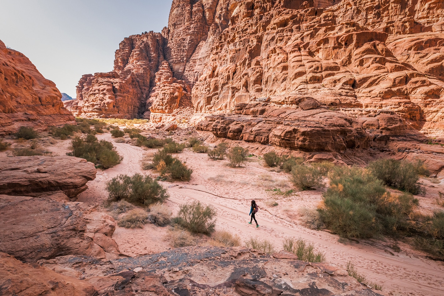
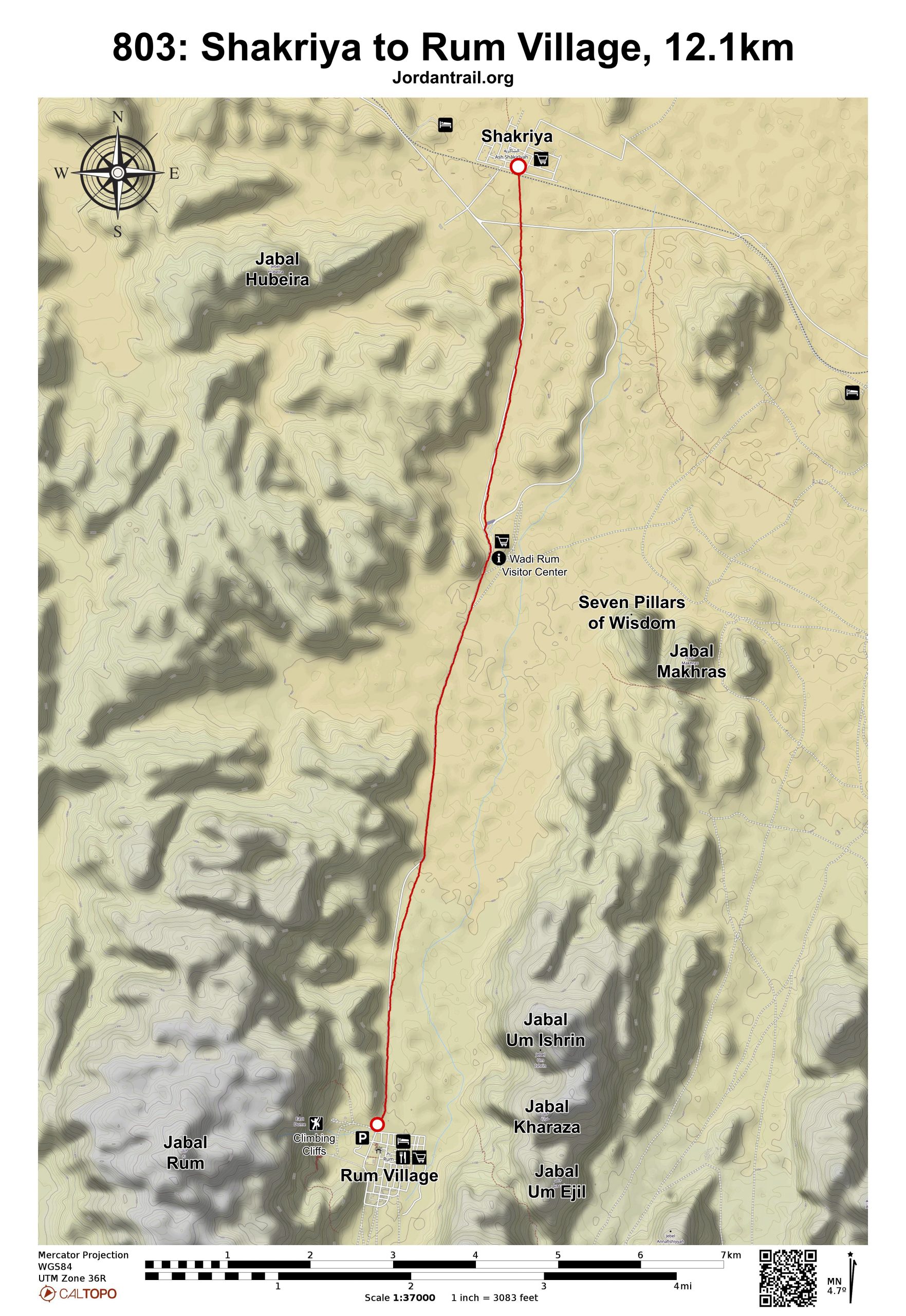
From Shakriya, head straight south, crossing the railroad tracks and a paved road to join the main road into the Wadi Rum Visitor’s Center visible ahead with a large entryway. From the Visitor Center, Rum village is visible straight-ahead 7km to the south.


Continue along the valley to the east of the road to pass farther from the traffic, or alternately walk right along the road all the way into the village to get there faster and take a break from the sand. The Wadi Rum Rest House is on the right at the entrance of Rum village, with small shops for resupply nearby.

TRANSTOPTATION
  • Rum-Aqaba bus, no fixed schedule, bus departs when driver feels like it
  • There is no bus from Rum to Petra
  • Private taxis on roads, and jeeps/pickups on unpaved desert roads
LOCAL CONTACTS / ACCOMMODATION
  • Wild camping, Abdullah Al Zalabieh, +962776976356
  • Wild camping, Abdullah Al Swalheen, +962797177347
THINGS TO SEE
  • Wadi Rum
  • The “Seven Pillars of Wisdom”
  • Jebel Rum
  • Jebel Um Ishrin
FOOD & WATER

Food:

  • Snacks and drinks available at Rum Visitor Center
  • Small shops in Rum village

Water:

  • Shakriya, Visitor Center and Rum village
TIPS & SAFETY

Tips:

  • Day is short and near the road. Many may prefer walk road faster and get in, or combine with the previous day stage.

Safety Info:

  • Loose footing – You will be walking through sand, unless you choose to walk the road.
  • Dehydration/heat exhaustion – Very little shade, but distances between villages and Visitor Center are not very long.
  • Military base – There is a military school in the village of Shakriya, which has not been an issue with any hikers.

The Jordan Trail is a newly established trail, and is not marked. It is therefore our strong recommendation that you hire a local guide for your safety as many sections are remote with limited water sources and at times no connectivity.
By downloading these maps/GPX you take full responsibility for their use and accuracy; Jordan Trail Association does not warrant the accuracy or completeness of the information, materials or the reliability of any maps as they provided AS IS without warranty of any kind, either express or implied, including but not limited to, fitness for a particular purpose, or non-infringement ;You acknowledge that any reliance on any such maps, shall be at your sole risk and responsibility as Hiking, backpacking, and other outdoor activities all have potential hazards involving risk of injury or death. Outdoor activities have inherent risks and you should ensure you have the skill level and abilities suitable for the activities in Jordan to partake in them and to take all precaution measures.  Check the data on Google Earth or other Apps or Programs before using them.  The Jordan Trail Association shall not be held responsible for any incidents that may occur during your participation in any activity and/or by using any of the maps/GPX.
AGREE
close-link