SECTION 502: TOR AL-TABOUN TO KARAKA

  • HIKES IN THE REGION

  • DAY 2: TOR AL-TABOUN TO KARAKA

  • Distance: 21 km

  • Time: 6 - 8 hours

  • Physical Challenge: Moderate

  • Trail Challenge: Difficult

  • Waymarked: No

To download the GPS track, click icon

The Jordan Trail is a newly established trail, and is not marked. It is therefore our strong recommendation that you hire a local guide for your safety as many sections are remote with limited water sources and at times no connectivity.
By downloading these maps/GPX you take full responsibility for their use and accuracy; Jordan Trail Association does not warrant the accuracy or completeness of the information, materials or the reliability of any maps as they provided AS IS without warranty of any kind, either express or implied, including but not limited to, fitness for a particular purpose, or non-infringement ;You acknowledge that any reliance on any such maps, shall be at your sole risk and responsibility as Hiking, backpacking, and other outdoor activities all have potential hazards involving risk of injury or death. Outdoor activities have inherent risks and you should ensure you have the skill level and abilities suitable for the activities in Jordan to partake in them and to take all precaution measures.  Check the data on Google Earth or other Apps or Programs before using them.  The Jordan Trail Association shall not be held responsible for any incidents that may occur during your participation in any activity and/or by using any of the maps/GPX.
AGREE
close-link
Click Icon to download the map
IMPORTANT NUMBERS

Tourism Police:

Hotline: 117777
What’s App: +962 7 7099 1814

* When contacting Tourism Police for emergency identify that you are hiking the Jordan Trail, state your nationality, location and map name & number.


JTA office: +962 6 461 0999

(Working Hours: 9:00 a.m. to 5:00 p.m., Sunday- Thursday)

BASIC INFO
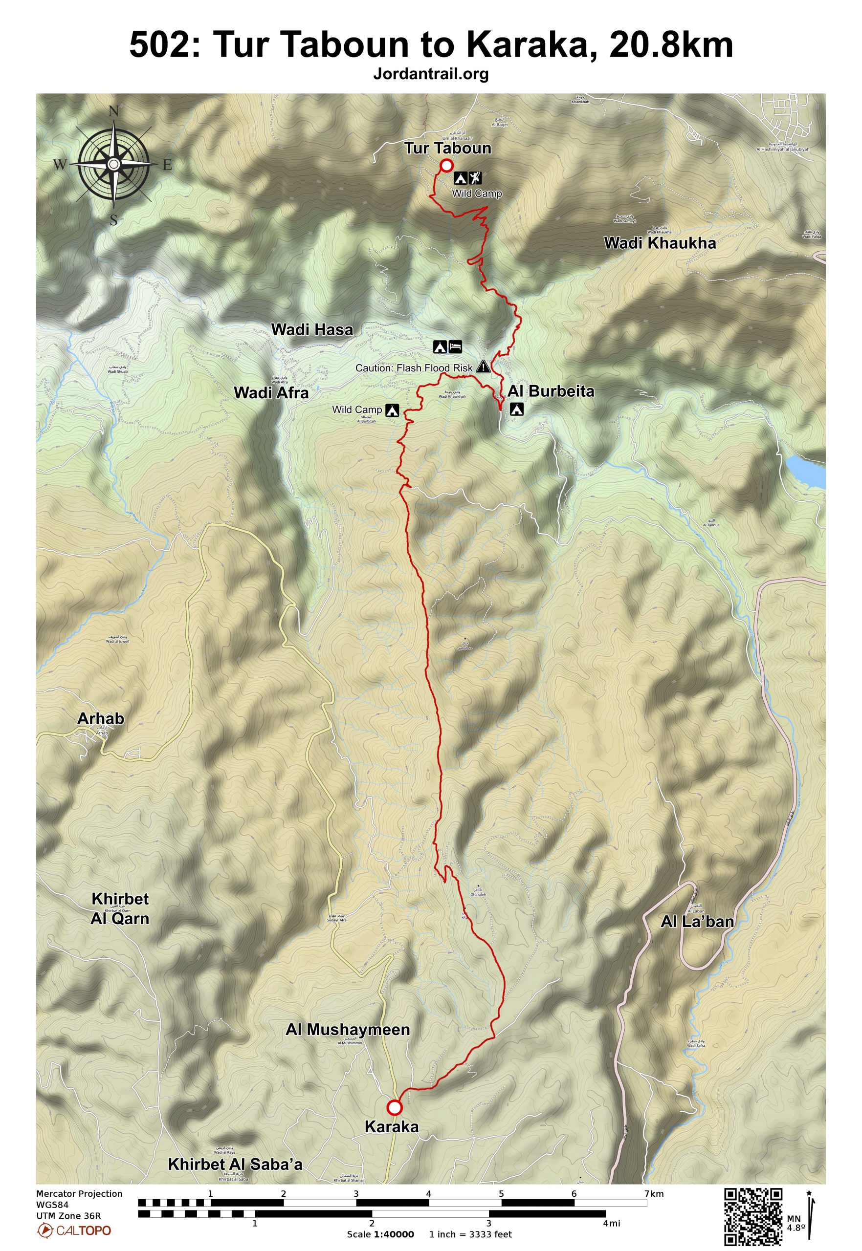
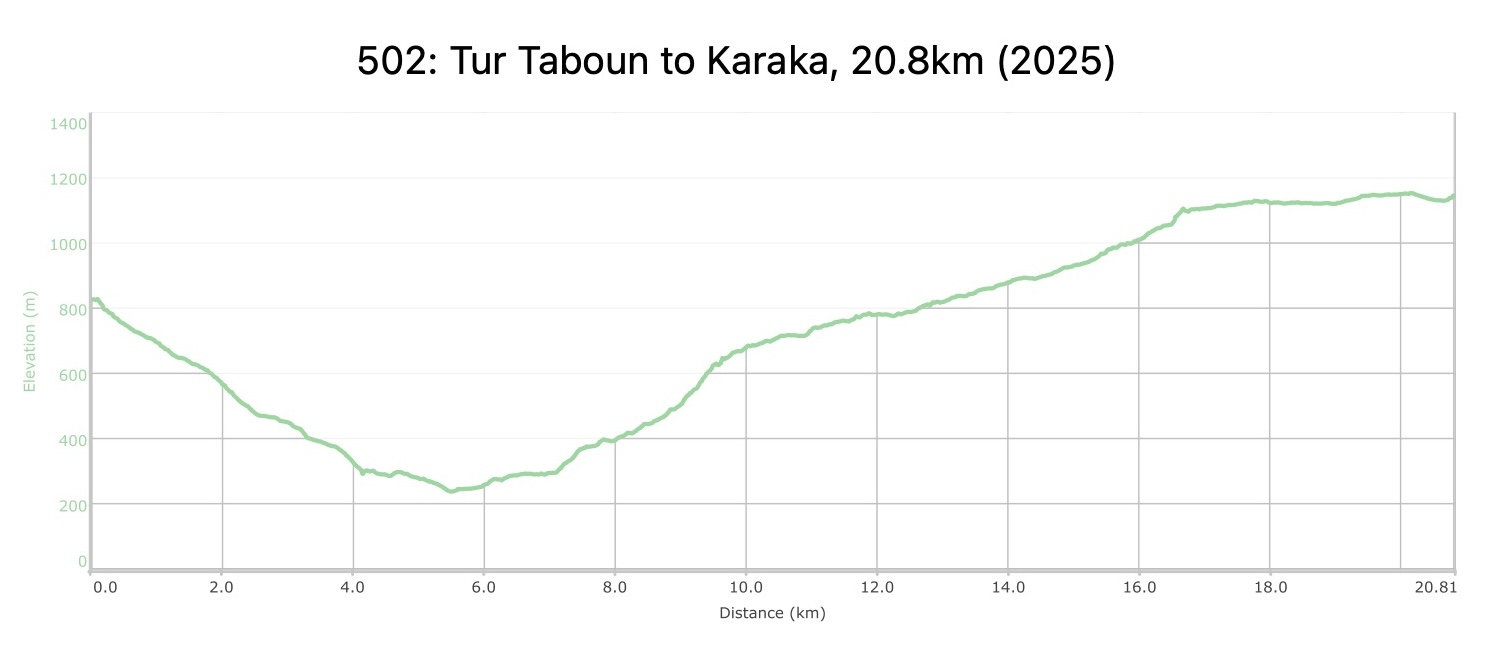
From the impressive cliffs of Tor Taboun, descend on a track, continue down, zig zagging into the depths of the canyon to reach a small stream, palms and gardens. Continue through the gardens following the track through the river to Burbeita Hot Springs. Fresh from the hot springs, you have a long but pleasant uphill walk to start the day, winding up over the shoulders of a broad ridge with great views both up and down the canyon (and a camp of Jahaleen Bedouin not far to the W). Just before cresting the ridge a track is met which heads S along the ridge. Small roads then continue S to Karaka.
TRANSTOPTATION
  • Minibuses passing paved road near Karaka.
  • Many sections of this stage are accessible by vehicle.
LOCAL CONTACTS / ACCOMMODATIONS
  • Wild Camping, Majed Alodainat, +962 777547548
THINGS TO SEE
  • Tor Taboun
  • Wadi Hasa (Beautiful Wadi, possible to follow all the way to the Dead Sea).
  • Khirbet At-Tannur
FOOD & WATER

Food:

  • The Burbeita area has minimarket, but open hours are not reliable.

Water:

  • Water from Wadi Hasa stream needs purification before drinking.
  • Burbeita or farms nearby
  • Qasrein spring
  • Farms in the Karaka area.
TIPS & SAFETY

Tips:

  • This is a long day with a long climb out of Wadi Hasa; but once on the plateau, the hiking becomes easier. The climb is not very steep, just long.
  • The descent from Tur Taboun is mostly on easy 4×4 roads, a little rockier towards the bottom.
  • From the Karaka junction, you can catch a shared taxi to Ais to skip the road part.
  • For camping, better to camp either near Wadi Hasa / Burbeita, near the Qasrein spring, or perhaps near the first farm before the stage ends in more built up areas.
  • Bathrooms can be found at Burbeita hot springs.

Safety Info:

  • Flash flood dangers – crossing wadi before Hasa and Wadi Hasa
  • Dehydration/heat exhaustion – Limited shade on route, especially for long climb out of Wadi Hasa.

The Jordan Trail is a newly established trail, and is not marked. It is therefore our strong recommendation that you hire a local guide for your safety as many sections are remote with limited water sources and at times no connectivity.
By downloading these maps/GPX you take full responsibility for their use and accuracy; Jordan Trail Association does not warrant the accuracy or completeness of the information, materials or the reliability of any maps as they provided AS IS without warranty of any kind, either express or implied, including but not limited to, fitness for a particular purpose, or non-infringement ;You acknowledge that any reliance on any such maps, shall be at your sole risk and responsibility as Hiking, backpacking, and other outdoor activities all have potential hazards involving risk of injury or death. Outdoor activities have inherent risks and you should ensure you have the skill level and abilities suitable for the activities in Jordan to partake in them and to take all precaution measures.  Check the data on Google Earth or other Apps or Programs before using them.  The Jordan Trail Association shall not be held responsible for any incidents that may occur during your participation in any activity and/or by using any of the maps/GPX.
AGREE
close-link