SECTION 603: RAS AL-FEID TO LITTLE PETRA

  • HIKES IN THE REGION

  • DAY 3: RAS AL-FEID TO LITTLE PETRA

  • Distance: 22.8 km

  • Time: 6 - 8 hours

  • Physical Challenge: Difficult

  • Trail Challenge: Difficult

  • Waymarked: No

To download the GPS track, click icon  

The Jordan Trail is a newly established trail, and is not marked. It is therefore our strong recommendation that you hire a local guide for your safety as many sections are remote with limited water sources and at times no connectivity.
By downloading these maps/GPX you take full responsibility for their use and accuracy; Jordan Trail Association does not warrant the accuracy or completeness of the information, materials or the reliability of any maps as they provided AS IS without warranty of any kind, either express or implied, including but not limited to, fitness for a particular purpose, or non-infringement ;You acknowledge that any reliance on any such maps, shall be at your sole risk and responsibility as Hiking, backpacking, and other outdoor activities all have potential hazards involving risk of injury or death. Outdoor activities have inherent risks and you should ensure you have the skill level and abilities suitable for the activities in Jordan to partake in them and to take all precaution measures.  Check the data on Google Earth or other Apps or Programs before using them.  The Jordan Trail Association shall not be held responsible for any incidents that may occur during your participation in any activity and/or by using any of the maps/GPX.
AGREE
close-link
Click Icon to download the map
IMPORTANT NUMBERS

Tourism Police:

Hotline: 117777
What’s App: +962 7 7099 1814

* When contacting Tourism Police for emergency identify that you are hiking the Jordan Trail, state your nationality, location and map name & number.


JTA office: +962 6 461 0999

(Working Hours: 9:00 a.m. to 5:00 p.m., Sunday- Thursday)

BASIC INFO
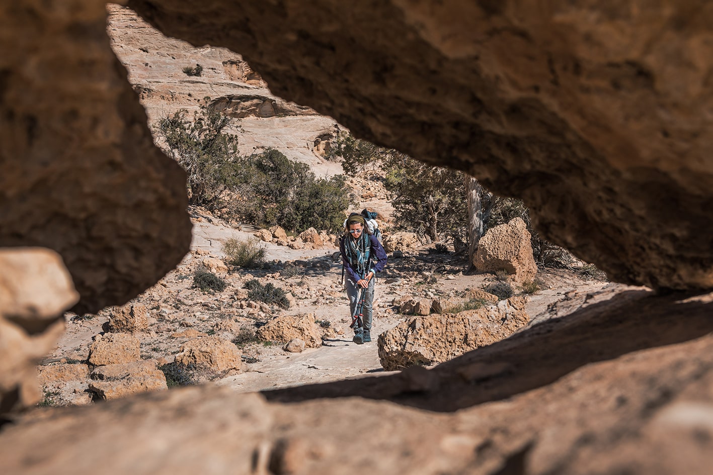
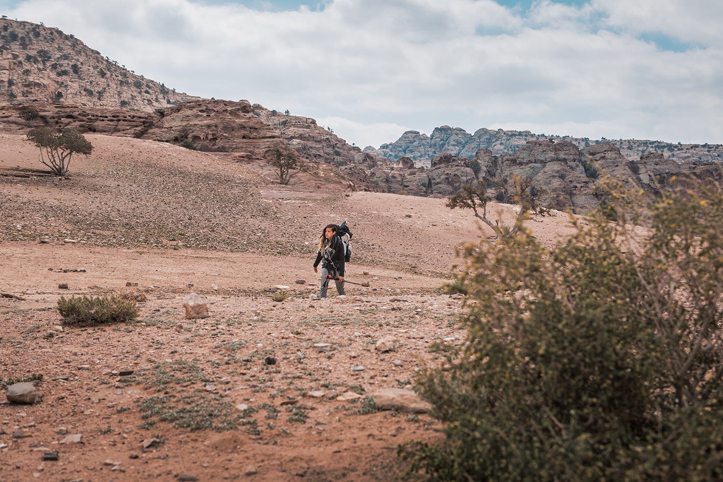
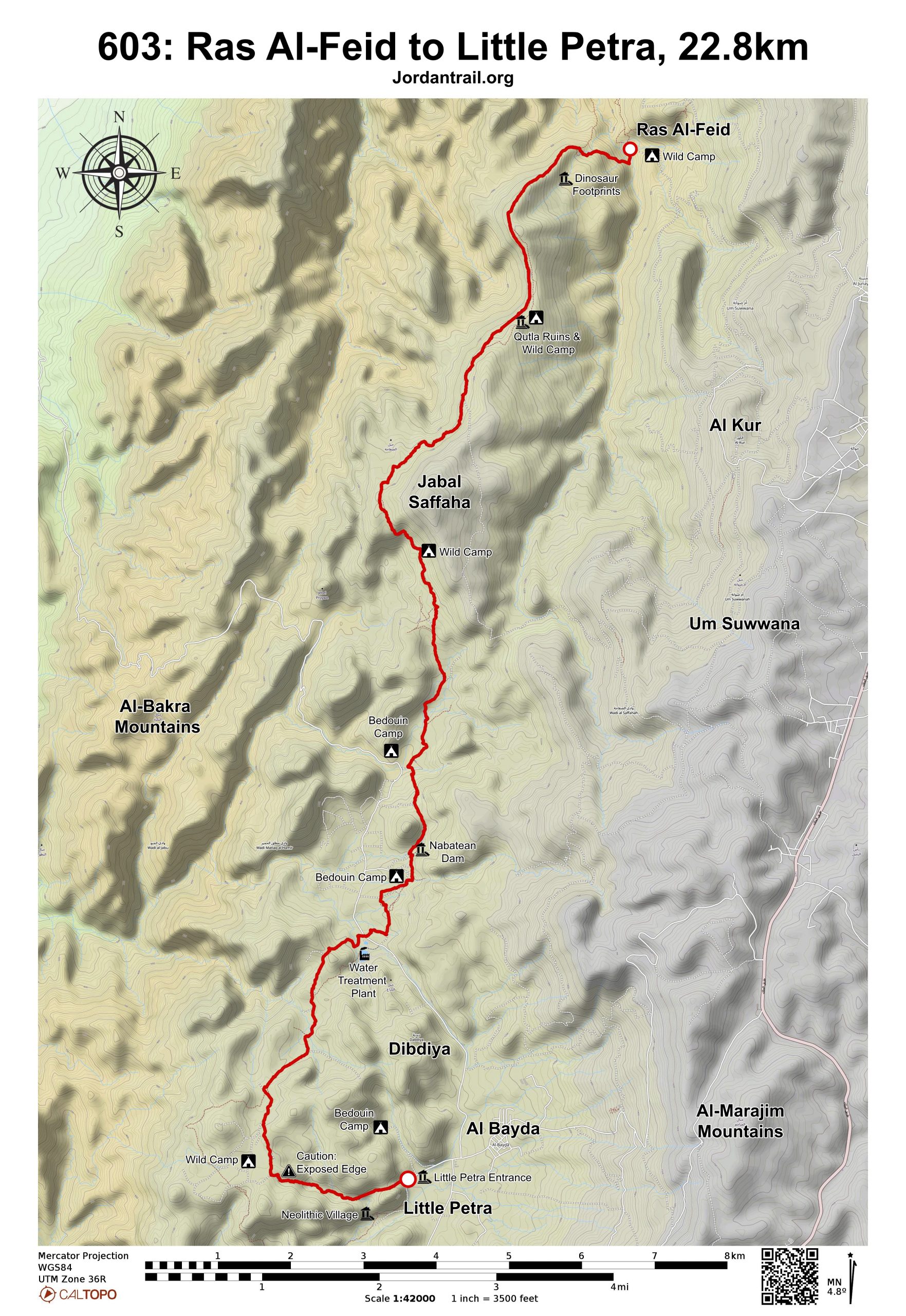
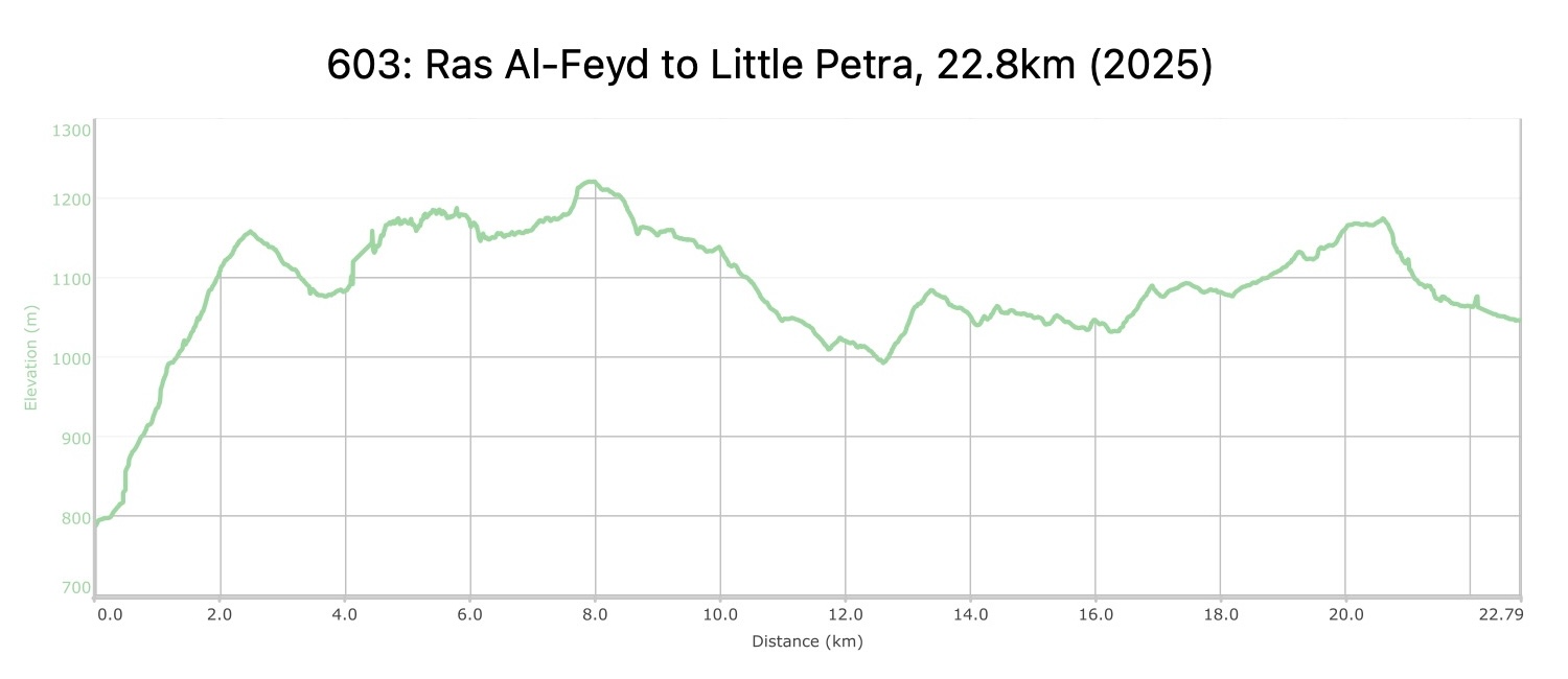
We leave Ras Al Feid along a rocky sandstone terrain. Throughout are spectacular varying views of the barren desert landscape with surprise encounters of desert vegetation and animal life. Approaching Little Petra there are signs of increasing human habitation of Bedouin camps, sheep pens, and small agricultural plots. We enter a small sandstone canyon and wind our way through to the site of Beihdah.
TRANSTOPTATION

The Ras al-Feid area is accessible only by jeep; the nearest village, Jahayir, is a 2-hour 4×4-drive away. Qbour al-Wahdat and al-Farsh areas are accessible by jeep and by the paved road that runs past the water treatment plant. There is no public transport to Little Petra, but public taxis are plentiful. Wadi Musa has the nearest bus terminal on the following day.

LOCAL CONTACTS / ACCOMMODATION
  • Ammarin Camp, +9620799755551, Hussain Ammarin, +962787452089, JT Pass Stamp Petra
  • Wild camping, Mohammad Ammarin, +962776306794
THINGS TO SEE
  • 360 views from Mt. Safaha
  • Neolithic, Nabatean and Roman ruins throughout the stage
  • Seashell fossils in sandstone
  • Little Petra and Siq al-Barid
FOOD & WATER

Food:

  • Snacks are available for purchase at Little Petra, and meals at Bedouin camps nearby or Ammarin Camp on the detour. Be sure to reserve in advance.

Water:

  • The Qutla ruins after Mt. Safaha offer hikers water sources used by local shepherds, but may be dry depeding on the time of year. Water requires purification before human consumption.
  • It is possible that there may be a guesthouse open in the Qbour al-Wahdat area, which offers food and water, and the general area (as well as around the water treatment plant) is populated. Rock Camp (and Ammarin Camp on the detour) can provide water. Water, bathrooms, and snack shops are all available at Little Petra.
  • Water is available in the pools and stream of Wadi Fayd on the previous day stage.
TIPS & SAFETY

Tips:

  • It’s a long day, so take enough water and start early.
  • If self-supported, consider camping near the pool mid-route of the previous stage, then pushing into Little Petra the next day.
  • Paths are well worn, but important to have GPS for a couple of key turns.
  • Trail is steep going up at beginning, and the sandstone path and last wadi into Little Petra require extra attention on their varied slopes of sandstone rocks.

Safety Info:

  • Flash flood dangers – Wadi al-Aqlat, the wadi leading to the back entrance of Little Petra, could be susceptible to flash flooding. This area can be circumnavigated using a shortcut from the water treatment plant, but this route tends to be less scenic. If coming from Eid’s campsites, route requires crossing Wadi Feid.
  • Loose footing – A few sections on sandstone are loose, but traction is good on the path.
  • Dehydration/heat exhaustion – Day stage can be hot and is shadeless for much of the route, but it’s not hard to find shade for breaks. Be sure to pack enough water.

Mobile Phone Coverage: Service is limited, but has been found on the ridge of Mt. Safaha, the top of Wadi al-Aghlat before Little Petra, and around Little Petra.

LOCAL CONTACTS

Guides, Luggage Transfer, and Camping Services:

  • Eid Al-Azazmeh: 0779265511/0797075683
  • Mohammad Defallah: 0799927199
  • Mohammad Zanoon (Local escort): 0788898675
  • Adnan Abu Ghorrah (Local Escort/ English speaking)- 0790821239- [email protected]


Little Petra:

Ammarin Cooperative Association/ Ammarin Camp (Hussain Ammarin): 078 745 2089 (Camping and Local Guiding Services)

The Jordan Trail is a newly established trail, and is not marked. It is therefore our strong recommendation that you hire a local guide for your safety as many sections are remote with limited water sources and at times no connectivity.
By downloading these maps/GPX you take full responsibility for their use and accuracy; Jordan Trail Association does not warrant the accuracy or completeness of the information, materials or the reliability of any maps as they provided AS IS without warranty of any kind, either express or implied, including but not limited to, fitness for a particular purpose, or non-infringement ;You acknowledge that any reliance on any such maps, shall be at your sole risk and responsibility as Hiking, backpacking, and other outdoor activities all have potential hazards involving risk of injury or death. Outdoor activities have inherent risks and you should ensure you have the skill level and abilities suitable for the activities in Jordan to partake in them and to take all precaution measures.  Check the data on Google Earth or other Apps or Programs before using them.  The Jordan Trail Association shall not be held responsible for any incidents that may occur during your participation in any activity and/or by using any of the maps/GPX.
AGREE
close-link